
In September 2022, students from several Norwegian universities gathered in Iceland to take measurements and discuss the predicted changes to the Arctic with warmer and wetter conditions under climate change scenarios. The course by PRISM and CHESS was scheduled such that we traveled to several field sites in the northern and north-eastern regions of Iceland. Though far from the more commonly visited southern glaciers and black sand beaches it is an area that sits on the border between temperate and Arctic weather systems and one that is especially sensitive to climate change.
The morning before our drive east from Akureyri to Raufarhöfn we detoured northwest for a bit, following the curves of the coastline and skimming through the sea fog hanging to the cliffsides before darting into the Tröllaskagi peninsula located in central north Iceland. We parked the cars on the edge of a hay field belonging to the Þrasastaðir farm and crossed an ice-cold river before heading up the flanks of the Móafellshyrna Mountain. As the sun brought some life back to our river-frozen feet, we hiked over the area on the hunt for our subject of the day’s topic; the consequences of mountain permafrost loss. Scrambling over a small ridge brought us right to the edge of a deep scar on the mountainside, one that had been formed 10 years prior nearly to the day of our visit by a massive debris slide. How different it would have looked then—snow covered, wet, and scattered with angular blocks of rock and ice. Time had softened the scene a bit and vegetation was establishing itself among the rocks, but the large and unsorted mounds were a clear sign of the significant landslide that was seen and heard by the residents in the valley right where our cars were parked. Now we were here to decipher the role climate change played in this event.
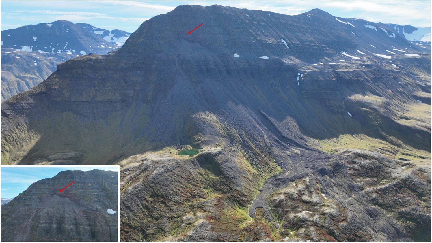 Figure 1: Móafellshyrna Mountain and debris slide scar taken with a drone September 6, 2022. The initiation zone is indicated by a red arrow in both the main photo and the inset (photo: PRISM drone photos).
Climate change is predicted to warm the Arctic faster than anywhere else. Iceland has seen a warming trend over their climate observations from the last 200 years with an acceleration since 1975. The Arctic is also predicted to experience an increase in precipitation. Iceland currently receives between 500 and 1000 mm per year in the north and central parts of the island which is comparable to many of the world’s Arctic regions. There can be upwards of 3000 mm per year in the south, more than even Bergen’s 2500 mm per year. Precipitation comes as snow and rain and the island can receive intense bouts of extreme weather.
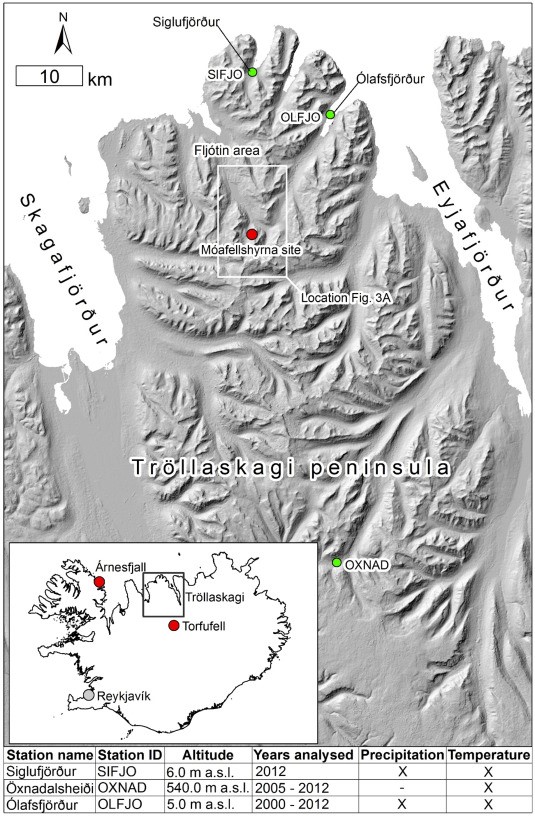 Figure 2: Location of Móafellshyrna Mountain in north central Iceland (figure from Sæmundsson et al., 2018).
Iceland is generally a place of extremes given its location right on the mid-Atlantic plate boundary and lying alone in the middle of the north Atlantic Ocean where weather and geologic activity define its existence. Two days after our site visit to Móafellshyrna Mountain most of our group was woken by the creaks and groans of our guest house as the earth shook us out of our sleep. A 5.1 magnitude earthquake and a few substantial aftershocks were an exciting way to become acquainted with Iceland’s geologic activity firsthand. The seismic activity in northern Iceland comes from three active lineaments from the Tjörnes Fracture Zone. It was one of those three faults that woke us up on September 8th, 2022 and it was from the same zone that three earthquakes of similar magnitude were recorded on September 19th and 20th 2012. It was not long after feeling those quakes that the residents of the Þrasastaðir farm heard rumbling noises from the peak above them and witnessed the snow-covered mountain crack and large blocks of debris come tumbling down onto the rocky slope below, right where we were standing 10 years later.
Glacial and permafrost landscapes, both of which are found in Iceland, are especially vulnerable to rapid changes and long-term increases in temperature. The permafrost landscapes in Iceland include those that people are most likely to think of when imagining permafrost, such as palsas and patterned ground. These are the sorts of features common in Alaska, Canada and Siberia where small, rolling hills are actually mounds of ice surrounded by soil, dirt, and vegetation. Iceland is also an area that includes mountain permafrost which is found in conjunction with rock glaciers and glacial moraine features. These areas of mountain permafrost were mapped using meteorological and geological inventories to model probable areas. Mountain permafrost is widespread in Iceland, particularly in the northern and eastern parts of the island, right where Móafellshyrna Mountain lies. As global temperatures rise and precipitation patterns change, permafrost and ground ice face thaw and collapse and cause a range of hazards from subsidence to debris slides.
Why is it that we didn’t hear of any landslides after the earthquake we experienced in September 2022? What is it about the Móafellshyrna event in 2012 that was unique? Researchers right after the event were in an enviable place. They had access to eyewitness accounts of the slide, seismic data, meteorological and climate data, as well as direct observations in the days after the slide when the slope had settled enough to be safely visited. The summer months prior to the slide were abnormally warm and dry, excellent conditions to thaw ground ice and permafrost. This period was followed by an unusually wet month where one third of the total rainfall for the year fell. Then, despite the warm spring and summer, the autumn was unusually cold. This cold snap helped researchers rule out the theory that thawing water from above triggered the slide, but that the permafrost table had been shifted due to the annual rise in temperatures and this deeper thawing led to an overall instability that just needed a little push to get going. That push was very likely the seismic events in the day and hours prior to the initiation of the slide itself.
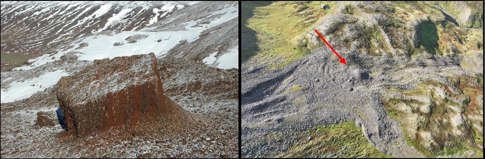 Figure 3: Left image of an ice-cemented block around 12 m wide and 4 m high (photo by Þorsteinn Sæmundsson September 29, 2012). Right image of the same block in the present day. The ice has melted leaving an unsorted mound (PRISM drone image September 6, 2022).
In contrast to 2012, our September excursion was sunny and balmy. We could observe evidence of the slide ourselves in full sunshine. The rock piles left on the slopes included a good mix of larger and smaller stones; an indication that they were not sorted by the physics of the slide itself but arrived at the spot all together in an intact boulder of rock and ice. The conclusions of researchers that the landslide was mainly caused by thawing permafrost rather than seismic activity can explain why the earthquakes our group got to experience weren’t particularly noteworthy. I am grateful for the beautiful weather that we had, but it helped to serve as a reminder that as the climate warms generally the chances increase that mountain permafrost in the peaks of the Tröllaskagi peninsula and beyond is thawing. The slope failure at Móafellshyrna Mountain was not the first landslide in Iceland attributed to permafrost thaw and it is unlikely to be the last.
References:
Etzelmüller, B., Patton, H., Schomacker, A., Czekirda, J., Girod, L., Hubbard, A., … & Westermann, S. (2020). Icelandic permafrost dynamics since the Last Glacial Maximum–model results and geomorphological implications. Quaternary Science Reviews, 233, 106236.
Lilleøren, K. S., Etzelmüller, B., Gärtner‐Roer, I., Kääb, A., Westermann, S., & Guðmundsson, Á. (2013). The distribution, thermal characteristics and dynamics of permafrost in Tröllaskagi, northern Iceland, as inferred from the distribution of rock glaciers and ice‐cored moraines. Permafrost and Periglacial Processes, 24(4), 322-335.
Sæmundsson, Þ., Morino, C., Helgason, J. K., Conway, S. J., & Pétursson, H. G. (2018). The triggering factors of the Móafellshyrna debris slide in northern Iceland: Intense precipitation, earthquake activity and thawing of mountain permafrost. Science of the total environment, 621, 1163-1175.
Acknowledgments: Thank you to CHESS and PRISM for hosting the course. Special thanks to A. Braaten and N. Bochow.
 0
0
 0
0 0
0 0
0 0
0 0
0