

Figure 1: Taken at 9 am on 16/01/2013 at the University of Hawai’i at Manoa campus.
Most people would think of Hawai’i as a place where you find perfect blue skies everyday of the year. In reality however, this is quite rarely the case. Usually the sky above Hawai’i is filled with scattered cumulus clouds moving with the trade winds and sometimes high-altitude cirrus clouds associated with the subtropical jet. Furthermore, we occasionally encounter frontal passages or heavy rain events associated with upper-troposphere disturbances called “Kona Lows”.

Figure 2: GFS Forecast for 8 am HST (18 UTC) on the 16/01/2013. Displayed are surface pressure (green contours), precipitation (shading) and 500-1000 hPa thickness (blue contours) as an indicator for the jet stream position.
On rare occasions however, we experience completely cloud-less blue skies. This weather phenomenon is called “Subsidence Blue” (Fig. 1.). Not a single cloud was visible in the entire sky on the morning of the 16th of January 2013, neither over the ocean nor the mountains. The conditions at 8 am this morning at the Honolulu airport were characterized by 17 °C air temperature, relative humidity of 75%, clear sky and light winds (2.5 m/s) from the northwest. The GFS forecast for the North Pacific at this time shows the large-scale circulation and precipitation pattern in the North Pacific (Fig. 2). In the following “climate snack” I want to briefly discuss the major atmospheric processes that lead to this phenomenon.

Figure 3: GFS Forecast for 8 am HST (18 UTC) on the 16/01/2013. Displayed are low-level (1000 hPa) winds (wind barbs).
The tail end of a front associated with a dissipating mid-latitude low-pressure system had just passed the island chain (Fig. 2). The model output shows that the Hawaiian Islands are now located just behind the frontal rainband, an area that is usually characterized by dry and cold air. Additionally we observe a relatively strong high-pressure system reaching the North American Pacific coast and a deep low-pressure system near the western end of the Aleutian Islands. The Intertropical Convergence Zone (ITCZ) is located at approx. 5-10°N.

Figure 4: GFS Forecast for 8 am HST (18 UTC) on the 16/01/2013. Displayed are upper-level (250 hPa) winds (wind barbs).
The conditions in Hawai’i are caused by the low-level northwesterly winds bringing cold and dry air from the extra-tropics to the islands (Fig. 3). Normal climatological conditions in Hawai’i are northeast trade winds. The model output for the upper-level (250 hPa) winds (Fig. 4) shows that the upper-level high-pressure system in the eastern Pacific blocks the jet-stream flow and causes the upper-level wind to bifurcate into two branches. Hawai’i is located in the south section of a jet streak exit region, which is characterized by upper-level convergence and low-level divergence. Hence, the jet streak exit contributes strongly to the subsidence regime. The clear sky over Hawai’i is visible via satellite (Fig. 5).

Figure 5: GOES satellite image (visible channel) of Hawai’i at 8.30 am HST on 16/01/2013.
The atmospheric sounding at Lihue for 2am that morning (Fig. 6) shows very stable conditions. The inversion is located at approx. 850 hPa and characterized by dry upper-level air (rapid decrease of the dewpoint temperature). The increase of the environmental temperature in the layer from approx. 850 hPa to 650 hPa is a characteristic of large-scale sinking air motion (subsidence). The dry air regime is captured well by the WRF model (Fig. 7).
Later that morning around 11am one could observe the formation of individual cumulus clouds near the Manoa hillside. The convection of air and accompanied cloud condensation was likely triggered by sensible heating of the land surface due to the increasing amount of incident shortwave radiation with the diurnal progression of the Sun.

Figure 6: Skew-T diagram for station Lihue at 2 am HST on 16/01/2013. The temperature (red line) and dewpoint (blue line) from the sounding are displayed as well as the wind magnitude and direction (barbs) and the moist adiabat (black line).
Molecular Rayleigh scattering explains the sky’s characteristic blue color during a strong subsidence regime, as Rayleigh scattering I increases with decreasing wavelengths λ, following the inverse relationship: 
In contrast, Mie scattering (favoring longer wavelengths) occurs mostly due to particles (aerosols) in the planetary boundary layer, resulting in hazy and grayish light. The characteristic blue observed on the 16th of January 2013 is also an indication of relatively low aerosol concentrations (e.g dust particles), which is mainly due to Hawai’i’s distance from large natural and anthropogenic dust and carbon aerosol sources. The only major aerosol sources are sea salt and volcanic sulfates from the Big Island during southerly wind conditions (“Kona Winds”). All model and satellite plots are taken from the University of Hawai’i weather server.
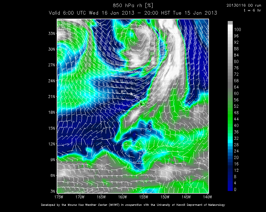
Figure 7: WRF model output for 8 pm HST on 15/01/2013. Relative humidity (shading) and wind (barbs) at the 850 hPa level are shown.
 0
0
 0
0 0
0 0
0 0
0 0
0Malte Stuecker
Latest posts by Malte Stuecker (see all)
- Subsidence Blue - April 12, 2013