
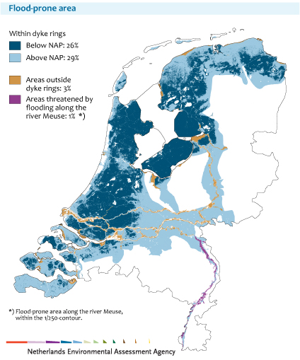
Figure Map of the Netherlands with areas vulnerable to flooding colour shaded. Areas below mean sea level (NAP) shaded dark blue, areas that would flood with every high tide shaded lighter blue, areas not protected by dikes or dunes shaded orange and areas threatened by the river Meuse shaded purple. source
The Netherlands, ‘Nederland’, its name literally means ‘low country’. In the CIA World Factbook it is described as a country that consists mostly of coastal lowland and reclaimed land (polders), with some hills in the southeast. It has 451 km of coastline and is located at the mouth of three big European rivers (Rhine, Meuse and Scheldt). The highest point lies 322 metres above mean sea level (Vaalserberg), the lowest point at -7 metres (Zuidplaspolder). [1]
These numbers are by no means extremes on Earth. By international standards the Vaalserberg (‘berg’ is Dutch for mountain) is probably not high or steep enough to officially be a mountain. Additionally, 7 metres below sea level is nothing compared to the Dead Sea’s elevation of -424 metres. However, the combination of the facts listed above does lead to an astonishing figure; 59% of the country’s land surface is vulnerable to flooding [2]. In this article I would like to give a short overview of the Dutch fight against the water, in the past and in a future warmer climate.
Historic developments
For centuries, Dutch engineers have claimed and defended territory from the North Sea and high river flooding. The first settlers in what is now the west of the Netherlands lived on small mounds in the middle of peat land that would flood with every high tide. To prevent this, the people built small primitive dikes to keep the land dry and suitable for agriculture. These were the first ‘polders’. However, over time the reclaimed land dried, settled and started sinking. Eventually in some places it would sink below sea level, and due to rain and seeping groundwater, the water would claim it back. It was the advent of the windmill in the 16th century that made the country what it is today; wind-powered pumps solved the drainage problem. In the centuries that followed, pumps were arranged in large networks, draining water in small steps: from a low polder, to a ditch, to a channel and finally to the river that would transport it to the sea.
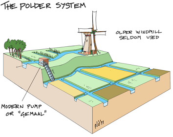
Figure Sketch of a wind-powered drainage system to create a polder. source
Despite this seemingly foolproof wind-powered system to keep land surfaces dry, the threat of the North Sea has on occasions defeated Dutch water management. Large floods have had a significant impact on people and policy. After a flood in 1916 the Afsluitdijk (Closure Dam) was built: a 32 km long dam that closed a potentially dangerous bay. IJsselmeer, the largest fresh lake of the Netherlands, was formed and later partly reclaimed. In 1953 a combination of a northwesterly storm and spring tide created a large storm surge and devastating flood. The Afsluitdijk protected the north, but dikes in the southwest failed. Villages were swept away and 1836 people died. In the years that followed the Delta Plan was developed, the execution of which only finished in 1997 with the building of the Delta Works. Years of engineering decreased the length of potentially dangerous coastline by 700 km (to the current 451 km of coastline) and closed every sea inlet with a dam, (moveable) barrier or lock.
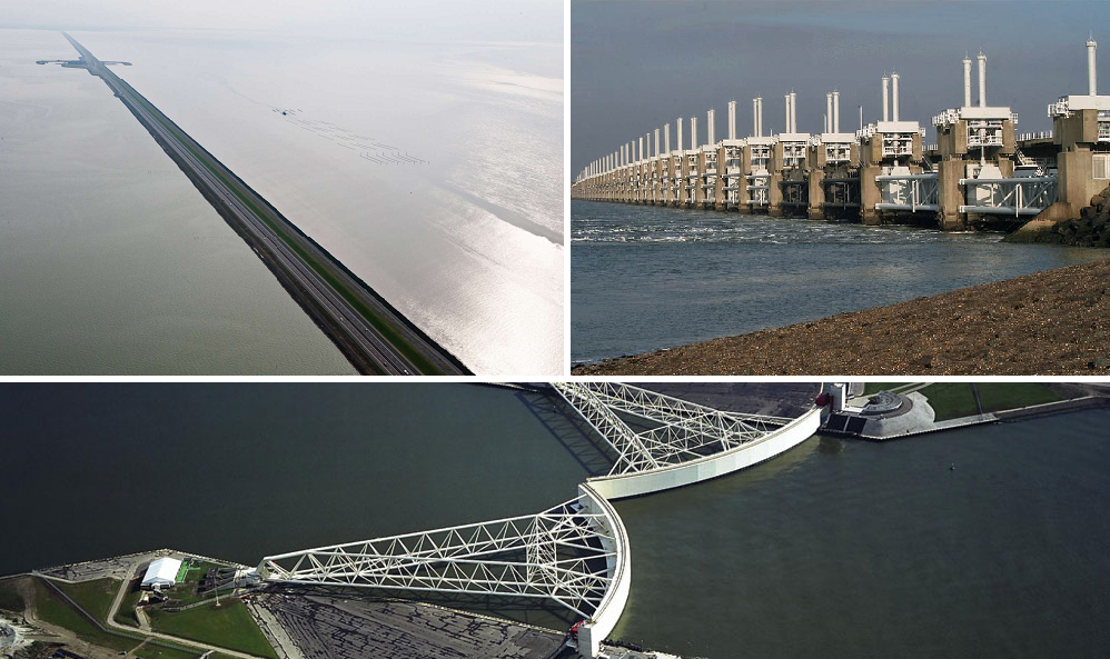
Figure Top left Afsluitdijk (completed 1933, source), top right Oosterscheldekering, doors can slide down to stop water going through (1986, source), bottom Maeslantkering, a moveable barrier at the entrance of the port of Rotterdam (1997, source).
A changing climate
The impacts of sea level rise due to climate change are a major and obvious concern. Perhaps less well-known is the potential danger of increased river discharge. In 2007 a new Delta Commission was established with the objective ‘to protect the Netherlands from flooding and to secure a sufficient supply of freshwater for the generations ahead‘. New strategies were developed, government funds secured and acceptable risks set in the law. From the year 2050 onwards, every citizen of the Netherlands living behind dunes and dikes will be protected to the same level, with the maximum risk of dying due to flooding to be 1/100,000 per year [3].
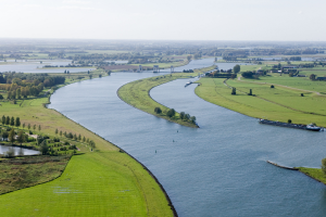
Figure Ruimte voor de Rivier at Neder-Rhine. source
To reach this level of safety, adaptations have to be made all over the country. Whilst the previous Delta Plan was focused on the threat by the sea; this time the largest reconstructions will be made in the river area. The ‘Ruimte voor de Rivier’ (Room for the river) project impacts the direct surroundings of rivers Rhine and Meuse in 30 locations. Riverbeds are deepened, flood plains cleared, dikes and villages relocated. In some cases the ultimate sacrifice is made- polders are given back to the water. All this work to enable the rivers to transport increased peak discharges caused by extreme precipitation in upstream catchment areas (the Alps, Germany, Belgium).
The current coastline will be maintained using beach nourishment. The North Sea is constantly eroding sand from the beaches and dunes, a vital link in coastal protection. Up to now, every five years sand is added to every beach to counteract the losses which repeatedly disrupts the sea floor ecosystem. At the moment, alternative dynamic coast management is being tested. In November 2011 a 1 km squared large peninsula was created in front of the coast, the ‘Zandmotor’ (Sand Engine). In time wind, waves, ocean currents and tides will move this sand along the coast to create broader beaches and dunes. This process is more natural than the previous method. A new ecosystem has been created and the beaches can hopefully be left unattended for a much longer period of time, whilst still providing the necessary protection.
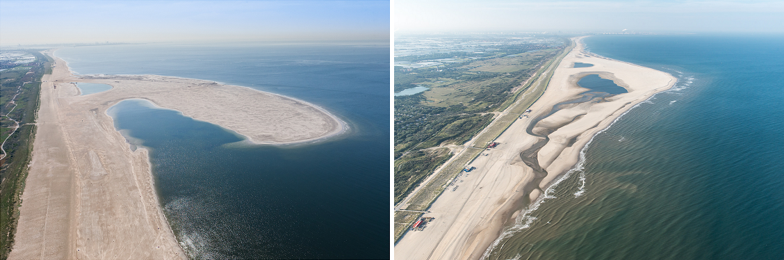
Figure The Zandmotor, left just before building was complete (June 2011, source), right after 2 years of natural development (October 2013, source).
Without doubt the Netherlands will experience the effects of a warmer climate. However, both technical and financial capacities make it possible to develop and implement strategies to deal with the changing threats. The Dutch fight against the water is never-ending; in the meantime lakes, rivers and the sea side provide the most wonderful places for swimming, sailing, or skating.
References
[1] CIA World Factbook, Europe, Netherlands https://www.cia.gov/library/publications/the-world-factbook/geos/nl.html
[2] Correction wording flood risks for the Netherlands in IPCC report http://www.pbl.nl/en/dossiers/Climatechange/content/correction-wording-flood-risks
[3] Delta Programme 2015 http://www.deltacommissaris.nl/english/Images/Delta%20Programme%202015%20English_tcm310-358177.pdf
 0
0
 0
0 0
0 0
0 0
0 0
0Karin van der Wiel
Latest posts by Karin van der Wiel (see all)
- How to respond to climate science denial - October 5, 2015
- Characteristics of climate science denial - July 3, 2015
- Flood management below sea level – strategies from the Netherlands - February 3, 2015